
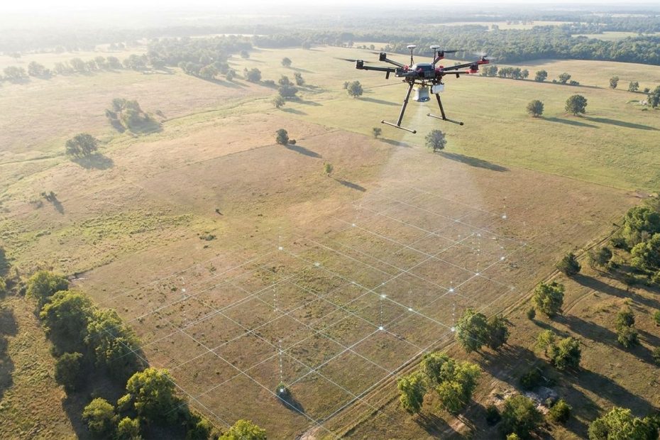
Drone mapping is becoming essential in property analysis because it turns a site into measurable visual data, not just a set of photos. You can review roofs, land contours, access points, drainage patterns, construction progress, and asset condition faster than many manual inspection methods allow.
For property professionals, that speed matters because delayed or incomplete site information can affect pricing, due diligence, underwriting, maintenance planning, and development decisions. This article explains what drone mapping does, how it differs from ordinary aerial photography, where it adds value, what it costs, and how to use it without creating legal or workflow problems.
What Is Drone Mapping?
Drone mapping is the process of using an unmanned aircraft to capture overlapping aerial images, then converting those images into measurable two-dimensional maps, three-dimensional models, elevation data, and site records. Regular drone photography shows you what a property looks like; drone mapping helps you measure, compare, and analyze it.
The difference matters when you’re making a property decision. A single aerial photo can show roof shape, driveway layout, or nearby trees, but it won’t reliably measure slope, surface area, stockpile volume, or changes across a job site. A mapped property can produce an orthomosaic map, which is a corrected aerial image stitched from many photos into one accurate top-down view.
You can also use drone mapping to build a three-dimensional point cloud or site model. That gives you a much better read on grade changes, retaining walls, building heights, drainage paths, pavement conditions, and development constraints. For property analysis, the value isn’t the drone itself. The value is structured site data you can use to make decisions with less guesswork.
How Does Drone Mapping Work?
Drone mapping works by capturing many overlapping images of a property, then using photogrammetry software to calculate measurements, positions, elevations, and surface models. With real-time kinematic positioning, post-processed kinematic positioning, and ground control points, the map can reach centimeter-level accuracy under the right conditions.
A typical mapping flight follows a planned grid over the site. The drone captures images at set intervals, with enough overlap for the software to match common points between photos. The system then builds outputs that can include an orthomosaic, digital surface model, digital terrain model, three-dimensional mesh, contour map, and georeferenced image layers.
The accuracy depends on flight height, camera quality, overlap settings, lighting, ground control, positioning hardware, and processing quality. Real-time kinematic and post-processed kinematic systems improve positioning by correcting location data, and ground control points anchor the model to known coordinates. That’s why drone mapping for property analysis should be treated as a technical workflow, not just a quick flight over a parcel.
Why Is Drone Mapping Becoming Essential In Property Analysis?
Drone mapping is becoming essential in property analysis because it reduces the time between seeing a property and understanding it. You get visual, measurable, and shareable records that support faster due diligence, better maintenance planning, and stronger site comparisons.
The market data points in the same direction. Grand View Research values the global drone mapping and surveying market at USD 2.7 billion and projects it to reach USD 8.5 billion by 2030. Drone Industry Insights reports that real estate drone services account for 19% of commercial drone deployments, and DroneDeploy reports broad weekly use among large construction firms for site monitoring and property analysis.
That adoption is happening because property teams need better site records. A buyer wants to know whether a parcel has grading issues. An asset manager wants to check roofs, pavement, drainage, and perimeter conditions without waiting for a slow inspection cycle. A lender or project owner wants visual proof that work is moving as expected. Drone mapping gives each party a shared source of site evidence.
How Accurate Are Drone Maps For Property Surveys?
Drone maps can be very accurate, but accuracy depends on the equipment, controls, and purpose of the work. Pix4D accuracy guidance notes that real-time kinematic or post-processed kinematic drones with ground control points can deliver about 1–3 centimeters horizontal accuracy and 2–5 centimeters vertical accuracy under suitable conditions.
That does not mean every drone map replaces a licensed land survey. If you’re resolving a boundary dispute, recording legal property lines, or relying on a sealed survey document, you still need the right licensed professional. Drone mapping is best understood as a strong measurement and analysis tool that can support survey work, site planning, construction monitoring, and property review.
The accuracy advantage becomes clear when you compare drone orthomosaics with many public aerial image sources. Drone imagery can reach 1–2 centimeters per pixel, making small details visible, including pavement cracking, roof wear, vegetation encroachment, bare soil, and drainage features. Public satellite imagery is useful for broad review, but it often lacks the resolution and freshness needed for detailed property analysis.
Where Does Drone Mapping Create The Most Value?
Drone mapping creates the most value when a property decision depends on physical site conditions, not just listing information or paper records. It helps you see what is present, measure what has changed, and document what needs attention.
In residential real estate, drone mapping supports pre-listing review, lot presentation, roof checks, and buyer education. National Association of REALTORS research reports stronger listing performance when aerial imagery is used, including faster sales and more views. For agents and sellers, the advantage is not just visual appeal. A mapped property can help explain lot shape, access, tree coverage, slope, and nearby features.
In commercial, industrial, land, construction, and insurance work, the value becomes more operational. You can monitor parking lots, roof sections, drainage systems, construction progress, cut and fill conditions, stockpiles, and exterior assets. Insurers and property managers can use repeated mapping to compare condition changes across time, which helps identify maintenance issues before they become more expensive.
- Residential Properties: Better listing visuals, lot review, and pre-listing condition checks.
- Commercial Assets: Faster review of roofs, pavement, access, drainage, and exterior systems.
- Land Development: Better understanding of slope, vegetation, grading, and feasibility constraints.
- Construction Sites: Progress records, lender updates, quantity checks, and site coordination.
- Insurance Work: Safer roof review, faster claim documentation, and better condition tracking.
When Does Drone Mapping Pay For Itself?
Drone mapping pays for itself when the cost of slower, less detailed, or more hazardous property review exceeds the cost of the flight and processing. That usually happens on larger parcels, commercial properties, construction sites, recurring inspections, or assets with roofs, slopes, drainage, or access issues.
Propeller Aero case material compares traditional surveying of a 20-acre site taking multiple field days with drone mapping that can capture the site in under two hours, with processing completed afterward. Fixr and commercial drone service pricing place many traditional land surveys in the USD 2,000–USD 5,000 range, with drone-based topographic mapping often priced lower for comparable parcels. Pricing still depends on location, airspace, deliverables, accuracy requirements, vegetation, site access, and whether a licensed surveyor must certify the work.
If you only need one set of marketing photos for a small home, full drone mapping may be more than you need. If you manage repeated inspections, construction draws, land acquisition, or commercial asset condition reviews, the economics change quickly. You reduce site visits, shorten reporting time, create better records, and make it easier for decision-makers to review the same property data from different locations.
What Legal Rules Apply To Commercial Drone Mapping?
In the United States, commercial drone mapping generally requires compliance with Federal Aviation Administration Part 107 rules. If you’re using a drone for real estate, inspection, construction, insurance, or any business purpose, you need the proper remote pilot certification or you need to hire someone who has it.
Legal planning also includes airspace checks, altitude limits, flight restrictions, visual line of sight requirements, and waiver needs for certain operations. A property owner’s permission does not automatically solve every airspace or privacy issue. You still need to operate safely, avoid unnecessary capture of neighboring properties, and plan flights around people, vehicles, weather, and nearby structures.
Hiring a qualified drone mapping provider can reduce the burden if your team does not want to manage certification, insurance, aircraft maintenance, and flight planning. Ask providers what deliverables they produce, how they handle ground control, what accuracy level they can support, and whether they carry suitable insurance. A low-cost flight is not a bargain if the data can’t support the decision you need to make.
How Do You Add Drone Data To Your Property Workflow?
You add drone data to your workflow by deciding what property question the map needs to answer before anyone flies. A good flight plan starts with the decision: valuation support, roof review, drainage study, construction progress, maintenance planning, land feasibility, or claim documentation.
Once the purpose is clear, choose the right deliverables. A listing team may need polished aerial visuals and a clean orthomosaic. A land development team may need elevation models, contours, and geographic information system layers. A construction team may need repeatable site maps, progress comparisons, quantity measurements, and shareable reports for owners or lenders.
Integration matters because drone files can become clutter if no one owns the process. Store maps, models, and reports with the same discipline you use for surveys, appraisals, inspection reports, drawings, and maintenance records. If your team uses geographic information system software, property management software, or building information modeling tools, confirm file compatibility before commissioning the work.
What Objections Should You Review Before You Invest?
The common objections are cost, accuracy, liability, training, weather, and data overload. None of these should be ignored, but none automatically make drone mapping a poor fit.
Cost is the first concern because mapping drones with advanced positioning can be expensive. Smaller teams do not always need to buy equipment, train pilots, and manage software subscriptions. Hiring a drone mapping provider can be a better entry point, especially when you need occasional property analysis rather than weekly flight operations.
Accuracy concerns are reasonable because not every drone operator produces survey-ready data. Ask how ground control points are used, what positioning system supports the flight, what accuracy report is provided, and whether a licensed surveyor is involved when legal boundaries matter. Liability concerns also need clear scope. A drone roof inspection can reduce ladder exposure, but your report should state what was reviewed, what was not visible, and what method was used.
How Will Drone Mapping Change Property Analysis?
Drone mapping will keep moving property analysis toward repeatable, measurable, and easier-to-share site records. The largest gains will come from better processing software, artificial intelligence-assisted defect detection, automated comparison between maps, and easier links between drone data and property systems.
For you, the practical change is simpler: you’ll be able to compare the same property across time with more confidence. A roof map from one quarter can be compared with the next. A construction site can be reviewed against schedule. A land parcel can be assessed for slope, access, and grading before deeper feasibility work begins.
Human judgment still matters. Drone mapping does not remove the need for inspectors, surveyors, appraisers, engineers, property managers, or experienced brokers. It gives those professionals better source material, cleaner records, and a faster way to spot issues worth a closer look.
Why Is Drone Mapping Becoming Essential In Property Analysis?
- Maps sites faster
- Measures land and assets
- Improves due diligence
- Reduces inspection risk
- Creates shareable property records
Build Better Property Decisions With Better Site Data
Drone mapping is becoming essential in property analysis because it closes the gap between seeing a property and understanding it. You get measurable maps, three-dimensional models, elevation data, and repeatable records that help you compare condition, risk, cost, and opportunity. It won’t replace licensed judgment where legal, engineering, or certified survey work is required, but it can make those decisions better informed. The best starting point is simple: define the property question, choose the right deliverable, confirm the operator’s qualifications, and keep the data organized where your team can use it. When you treat drone mapping as a decision tool rather than a visual add-on, it becomes one of the most practical upgrades in modern property analysis.
References:
- Federal Aviation Administration Commercial Drone Operators;
- Grand View Research Drone Mapping Software Market;
- National Association of REALTORS Technology Survey;
- DroneDeploy State of Drones in Construction;
- Propeller Aero Drone Surveying Versus Traditional Surveying;
- Pix4D Drone Mapping Accuracy;
- American Society for Photogrammetry and Remote Sensing;
- Royal Institution of Chartered Surveyors Drones in Property Measurement;
- Fixr Land Survey Cost Guide;
- Munich Re Drones in Industry;
- DJI Enterprise Drone Roof Inspections;
- United States Geological Survey Satellite Imagery Coverage

Chrysilios Chrysiliou is a commercial real estate executive at RDPH Properties, Inc. with a diverse background in aviation and entrepreneurship. A former Greek Air Force Academy graduate, flight instructor, and flight school co-owner, he now leverages decades of strategic leadership to identify and develop high-value real estate opportunities.